

| iMereb Business Management Solutions, Information Technology, Mapping & Cartography and Image Analysis |
| | | |
EXPERTISE / IMAGE ANALYSIS / SATELLITE IMAGERY / MT DIXON |
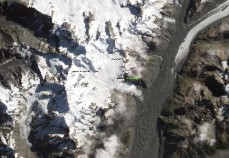
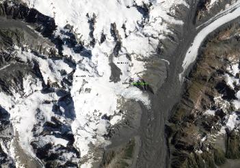
In mid-January 2013, a large landslide rumbled down the slopes of
one of New Zealand’s tallest mountains. The massive slide of rock, ice,
and snow on Mount Dixon occurred on January 21. The mountain lies
within Aoraki/Mount Cook National Park and is part of the range
dubbed the “Southern Alps.”
The Advanced Land Imager (ALI) on NASA’s Earth Observing-1
(EO-1) satellite captured these two views of the area around Mount
Dixon and Mount Cook/Aoraki. The top image was acquired on
February 5, 2013, two weeks after the landslide. For perspective, the
second image shows the same area roughly a year earlier, on March 13,
2012.
According to news reports and preliminary analysis, rock and ice
debris fell as much as 450 to 500 meters (1,500 to 1,600 feet) down a
near vertical face on the southern flank of Mount Dixon. Debris
continued to slide down Hochstetter glacier into the Grand Plateau,
spreading out over 3 kilometers (2 miles) and cascading down another
300 meters (1,000 feet) in elevation (800 meters total, or a half mile).
page 1 page 2