
| iMereb Business Management Solutions, Information Technology, Mapping & Cartography and Image Analysis |
| | | |
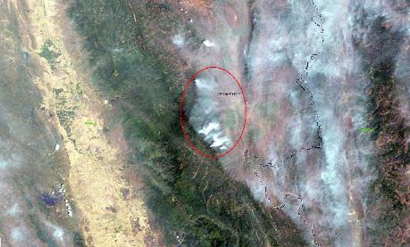
EXPERTISE / IMAGE ANALYSIS / SATELLITE IMAGERY/ BURMA FIRE |
This MODIS image is during the Asian monsoon season, it is cooler and
dry. Late in the dry season, fires become widespread (both intentional and
accidental) as people use burning to clear and maintain agricultural and
residential landscapes.
In permanently cultivated (usually lowland) areas, fires are used to burn
crop residues and get the land ready for the growing season. In urban and
residential areas, people burn leaves, trash, and brush. In the mountains,
fires may indicate permanent conversion of forest to agricultural land or
they may be associated with shifting cultivation, also known as swidden
farming. In this system, patches of forest are cyclically cut down, burned,
cultivated, and then left fallow for a time. Secondary forest or other
vegetation reclaims the clearing during the fallow period.
Fires have been part of the land management practices for hundreds to
thousands of years in this region, and they are not necessarily
hazardous...at least not immediately. The smoke from fires has a big
influence on air quality and human health, greenhouse gas emissions, the
carbon cycle, and biodiversity.
page 1 page 2